


vis

daco21
User
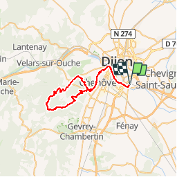

Length
47 km

Max alt
580 m

Uphill gradient
749 m
Km-Effort
57 km

Min alt
224 m

Downhill gradient
749 m
Boucle
Yes
Creation date :
2019-02-25 13:36:12.795
Updated on :
2019-02-25 13:36:12.879
3h43
Difficulty : Medium

FREE GPS app for hiking
 SityTrail
IGN / Geographical institutes
SityTrail Plus
The world is yours!
About
Trail Mountain bike of 47 km to be discovered at Bourgogne-Franche-Comté, Côte-d'Or, Longvic. This trail is proposed by daco21.
Positioning
Country:
France
Region :
Bourgogne-Franche-Comté
Department/Province :
Côte-d'Or
Municipality :
Longvic
Location:
Unknown
Start:(Dec)
Start:(UTM)
656310 ; 5239436 (31T) N.
Comments