Trail Walking Quistinic - Canal Nantes à Brest Jour 11 - Photo

Canal Nantes à Brest Jour 11

 copter
copter

User

© OpenStreetMap contributors
Length
Length
26 km
Max alt
Max alt
58 m
Uphill gradient
Uphill gradient
314 m
Km-Effort
Km-Effort  
30 km
Min alt
Min alt
0 m
Downhill gradient
Downhill gradient
342 m
Boucle
Boucle
No
Signpost
Signpost
Creation date :
2017-12-11 00:00:00.0
Updated on :
2017-12-11 00:00:00.0

(0 Reviews)

Walking
Walking
6h26
Difficulty : Medium

Scan this QR Code to open this trail in the SityTrail application

FREE GPS app for hiking

Logo SityTrail SityTrail

IGN / Geographical institutes

Download SityTrail from the App Store Download SityTrail from Google Play

Logo SityTrail SityTrail World

The world is yours!

Download SityTrail from the App Store Download SityTrail from Google Play Download SityTrail on Huawei AppGallery

About

Trail Walking of 26 km to be discovered at Brittany, Morbihan, Quistinic. This trail is proposed by copter.

Description

Canal de Nantes à Brest à pied.
Le Blavet.
Du Moulin de Prat Meur à Hennebont gare SNCF.

Elevation profile

Points of interest

Point of interest Hennebont - Gare SNCF - Photo
copter
HENNEBONT 

Positioning

Country:
France
Region :
Brittany
Department/Province :
Morbihan
Municipality :
Quistinic
Location:
Unknown
Start:(UTM)
492294 ; 5304328 (30T) N.

Trails nearby

Trail On foot Quistinic - Quistinic - circuit des Chapelles, boucle Sud - Photo
On foot
PRO

On foot

Medium
Quistinic, Brittany, Morbihan, France
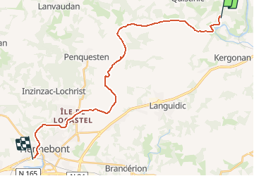
18.2 km | 24 km-effort
5h 22min
No
Trail Walking Quistinic - PR_56_Quistinic_BA_02_Circuit1b_Des-Chapelles-Nord_20240321 - Photo
Walking
patrickdanilo

Walking

Easy
Quistinic, Brittany, Morbihan, France
15.3 km | 18.8 km-effort
4h 15min
Yes
Trail Walking Saint-Barthélemy - PR_56_St-Barthelemy_BA_02_Circuit1b_Des-Ecureuils_20240302 - Photo
Walking
patrickdanilo

Walking

Easy
Saint-Barthélemy, Brittany, Morbihan, France
11.6 km | 13.8 km-effort
3h 8min
Yes
Trail Walking Quistinic - PR_56_Quistinic_AA_01_Circuit1b_De-Poul-Fetan_20230909 - Photo
Walking
patrickdanilo

Walking

Medium
Quistinic, Brittany, Morbihan, France
13.7 km | 17.3 km-effort
2h 54min
Yes
Trail Walking Baud - PR_56_Baud_AA_01_Circuit1b_Des-Landes-De-Kerbraz_20230212 - Photo
Walking
patrickdanilo

Walking

Difficult
Baud, Brittany, Morbihan, France
10.8 km | 13.1 km-effort
2h 21min
Yes
Trail Walking Quistinic - GR341-Quistinic
Walking
AHervé56

Walking

Very difficult
Quistinic, Brittany, Morbihan, France
17.8 km | 21 km-effort
4h 46min
No
Trail Equestrian Quistinic - De Quistinic à Bubry par les deux chapelles - Photo
Equestrian
tracegps

Equestrian

Medium
Quistinic, Brittany, Morbihan, France
31 km | 35 km-effort
4h 0min
Yes
Trail Walking Saint-Barthélemy - Circuit des Écureuils - Photo
Walking
xl1954

Walking

Easy
Saint-Barthélemy, Brittany, Morbihan, France
11.8 km | 14 km-effort
2h 59min
Yes
Trail Equestrian Languidic - De Pont Augan à St Adrien - Photo
Equestrian
tracegps

Equestrian

Medium
Languidic, Brittany, Morbihan, France
20 km | 25 km-effort
3h 0min
Yes


Close
My subscriptions