


69 GIVORS LE LAQUET

trietsch
User
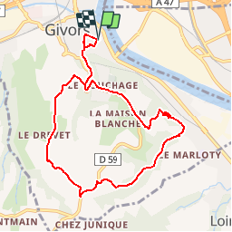

Length
9.1 km

Max alt
362 m

Uphill gradient
303 m
Km-Effort
13.1 km

Min alt
159 m

Downhill gradient
302 m
Boucle
Yes
Creation date :
2016-04-03 00:00:00.0
Updated on :
2020-01-04 20:29:53.954
2h47
Difficulty : Unknown

FREE GPS app for hiking
 SityTrail
IGN / Geographical institutes
SityTrail Plus
The world is yours!
About
Trail Walking of 9.1 km to be discovered at Auvergne-Rhône-Alpes, Métropole de Lyon, Givors. This trail is proposed by trietsch.
Positioning
Country:
France
Region :
Auvergne-Rhône-Alpes
Department/Province :
Métropole de Lyon
Municipality :
Givors
Location:
Unknown
Start:(Dec)
Start:(UTM)
638516 ; 5049254 (31T) N.
Comments