


Marseille Vieux Port St Charles

ARPF
User
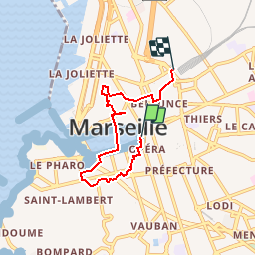

Length
5.3 km

Max alt
60 m

Uphill gradient
148 m
Km-Effort
7.2 km

Min alt
-2 m

Downhill gradient
102 m
Boucle
No
Creation date :
2016-11-14 00:00:00.0
Updated on :
2016-11-14 00:00:00.0
1h35
Difficulty : Easy

FREE GPS app for hiking
 SityTrail
IGN / Geographical institutes
SityTrail Plus
The world is yours!
About
Trail Walking of 5.3 km to be discovered at Provence-Alpes-Côte d'Azur, Bouches-du-Rhône, Marseille. This trail is proposed by ARPF.
Description
Du vieux port à St Charles en passant par le jardin Puget l'ABBAYE ST VICTOR et le quartier du Panier.
Positioning
Country:
France
Region :
Provence-Alpes-Côte d'Azur
Department/Province :
Bouches-du-Rhône
Municipality :
Marseille
Location:
1st Arrondissement
Start:(Dec)
Start:(UTM)
692583 ; 4796298 (31T) N.
Comments