


sortie vtt 08042016

fabwin
User GUIDE

Length
45 km

Max alt
328 m

Uphill gradient
449 m
Km-Effort
51 km

Min alt
229 m

Downhill gradient
449 m
Boucle
Yes
Creation date :
2016-04-08 00:00:00.0
Updated on :
2016-04-08 00:00:00.0
2h50
Difficulty : Medium

FREE GPS app for hiking
 SityTrail
IGN / Geographical institutes
SityTrail Plus
The world is yours!
About
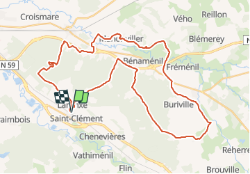
Trail Mountain bike of 45 km to be discovered at Grand Est, Meurthe-et-Moselle, Saint-Clément. This trail is proposed by fabwin.
Description
Laronxe Hablainville Petoncourt manonviller thiebaumenil Mondon
Avec Jojo & David
Positioning
Country:
France
Region :
Grand Est
Department/Province :
Meurthe-et-Moselle
Municipality :
Saint-Clément
Location:
Unknown
Start:(Dec)
Start:(UTM)
323021 ; 5378524 (32U) N.
Comments
Super tour de vtt je le recommande !