


Pic de Sarrouyes

philou6351
User
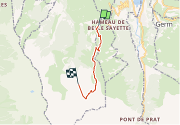

Length
6.7 km

Max alt
2633 m

Uphill gradient
1125 m
Km-Effort
18.2 km

Min alt
1579 m

Downhill gradient
76 m
Boucle
No
Creation date :
2016-04-08 00:00:00.0
Updated on :
2016-04-08 00:00:00.0
3h52
Difficulty : Unknown

FREE GPS app for hiking
 SityTrail
IGN / Geographical institutes
SityTrail Plus
The world is yours!
About
Trail Walking of 6.7 km to be discovered at Occitania, Hautespyrenees, Azet. This trail is proposed by philou6351.
Points of interest


Positioning
Country:
France
Region :
Occitania
Department/Province :
Hautespyrenees
Municipality :
Azet
Location:
Unknown
Start:(Dec)
Start:(UTM)
285797 ; 4741054 (31T) N.
Comments