s p

reymond83
User
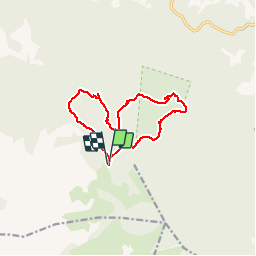

Length
12.4 km

Max alt
822 m

Uphill gradient
422 m
Km-Effort
18 km

Min alt
442 m

Downhill gradient
417 m
Boucle
Yes
Creation date :
2018-04-11 23:38:59.695
Updated on :
2018-04-11 23:38:59.695
4h03
Difficulty : Unknown

FREE GPS app for hiking
 SityTrail
IGN / Geographical institutes
SityTrail Plus
The world is yours!
About
Trail Other activity of 12.4 km to be discovered at Provence-Alpes-Côte d'Azur, Var, Signes. This trail is proposed by reymond83.
Positioning
Country:
France
Region :
Provence-Alpes-Côte d'Azur
Department/Province :
Var
Municipality :
Signes
Location:
Unknown
Start:(Dec)
Start:(UTM)
737158 ; 4790635 (31T) N.
Comments