


fontaine didier

XavierFaidix
User
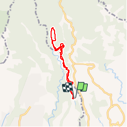

Length
8 km

Max alt
356 m

Uphill gradient
467 m
Km-Effort
14.2 km

Min alt
151 m

Downhill gradient
474 m
Boucle
Yes
Creation date :
2019-04-01 20:34:46.328
Updated on :
2019-04-01 20:34:46.373
51m
Difficulty : Very easy

FREE GPS app for hiking
 SityTrail
IGN / Geographical institutes
SityTrail Plus
The world is yours!
About
Trail Running of 8 km to be discovered at Martinique, Unknown, Schœlcher. This trail is proposed by XavierFaidix.
Positioning
Country:
France
Region :
Martinique
Department/Province :
Unknown
Municipality :
Schœlcher
Location:
Unknown
Start:(Dec)
Start:(UTM)
706293 ; 1619192 (20P) N.
Comments