


Vauvert lesCostieres

grageot
User
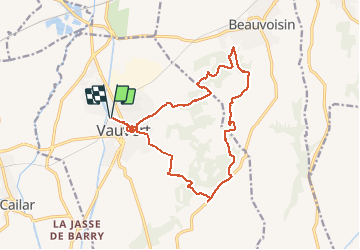

Length
18 km

Max alt
110 m

Uphill gradient
250 m
Km-Effort
21 km

Min alt
19 m

Downhill gradient
251 m
Boucle
Yes
Creation date :
2016-04-14 00:00:00.0
Updated on :
2016-04-14 00:00:00.0
4h27
Difficulty : Easy

FREE GPS app for hiking
 SityTrail
IGN / Geographical institutes
SityTrail Plus
The world is yours!
About
Trail Walking of 18 km to be discovered at Occitania, Gard, Vauvert. This trail is proposed by grageot.
Description
Ballade sans difficulté dans les bois et vallons des Costières : à voir les salines demander explications, une petite visite dans le vieux Vauveert pour la fin avec montée au Castellas
Positioning
Country:
France
Region :
Occitania
Department/Province :
Gard
Municipality :
Vauvert
Location:
Unknown
Start:(Dec)
Start:(UTM)
602453 ; 4838852 (31T) N.
Comments