


Illiers Combray 19

togolo28
User
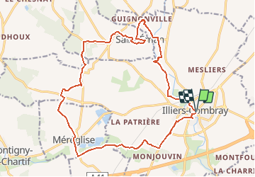

Length
19.6 km

Max alt
188 m

Uphill gradient
124 m
Km-Effort
21 km

Min alt
151 m

Downhill gradient
128 m
Boucle
Yes
Creation date :
2016-04-14 00:00:00.0
Updated on :
2020-07-24 17:19:49.998
4h44
Difficulty : Medium

FREE GPS app for hiking
 SityTrail
IGN / Geographical institutes
SityTrail Plus
The world is yours!
About
Trail Walking of 19.6 km to be discovered at Centre-Loire Valley, Eure-et-Loir, Illiers-Combray. This trail is proposed by togolo28.
Positioning
Country:
France
Region :
Centre-Loire Valley
Department/Province :
Eure-et-Loir
Municipality :
Illiers-Combray
Location:
Unknown
Start:(Dec)
Start:(UTM)
369836 ; 5351001 (31U) N.
Comments