


pic saint loup

narberd
User
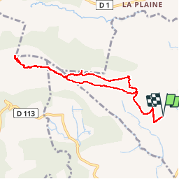

Length
9.7 km

Max alt
645 m

Uphill gradient
533 m
Km-Effort
16.9 km

Min alt
153 m

Downhill gradient
535 m
Boucle
Yes
Creation date :
2018-09-01 21:11:25.091
Updated on :
2018-09-01 21:11:25.115
3h32
Difficulty : Medium

FREE GPS app for hiking
 SityTrail
IGN / Geographical institutes
SityTrail Plus
The world is yours!
About
Trail Walking of 9.7 km to be discovered at Occitania, Hérault, Saint-Mathieu-de-Tréviers. This trail is proposed by narberd.
Description
Ascension du Pic saint loup depuis Saint Mathieu en passant par le Château de Montferrand
Prévoir de bonnes chaussures.
Positioning
Country:
France
Region :
Occitania
Department/Province :
Hérault
Municipality :
Saint-Mathieu-de-Tréviers
Location:
Unknown
Start:(Dec)
Start:(UTM)
568242 ; 4846503 (31T) N.
Comments