


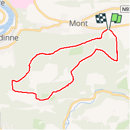
Mont-Godinne - Tricointe Perso_backup

vindju
User

Length
7.5 km

Max alt
287 m

Uphill gradient
191 m
Km-Effort
10 km

Min alt
186 m

Downhill gradient
195 m
Boucle
Yes
Creation date :
2019-05-07 13:28:49.222
Updated on :
2019-05-07 13:28:49.403
1h40
Difficulty : Easy

FREE GPS app for hiking
 SityTrail
IGN / Geographical institutes
SityTrail Plus
The world is yours!
About
Trail Walking of 7.5 km to be discovered at Wallonia, Namur, Yvoir. This trail is proposed by vindju.
Description
Belle promenade dans la forêt domaniale de Tricointe
Positioning
Country:
Belgium
Region :
Wallonia
Department/Province :
Namur
Municipality :
Yvoir
Location:
Mont
Start:(Dec)
Start:(UTM)
636007 ; 5579533 (31U) N.
Comments