


randogps pourcieux mont aurelien

Sugg
User
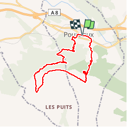

Length
15.7 km

Max alt
875 m

Uphill gradient
699 m
Km-Effort
25 km

Min alt
351 m

Downhill gradient
700 m
Boucle
Yes
Creation date :
2019-03-22 16:59:14.329
Updated on :
2019-03-22 16:59:14.393
--
Difficulty : Unknown

FREE GPS app for hiking
 SityTrail
IGN / Geographical institutes
SityTrail Plus
The world is yours!
About
Trail Walking of 15.7 km to be discovered at Provence-Alpes-Côte d'Azur, Var, Pourcieux. This trail is proposed by Sugg.
Positioning
Country:
France
Region :
Provence-Alpes-Côte d'Azur
Department/Province :
Var
Municipality :
Pourcieux
Location:
Unknown
Start:(Dec)
Start:(UTM)
725579 ; 4816630 (31T) N.
Comments