


Vasselay

jlrayon
User
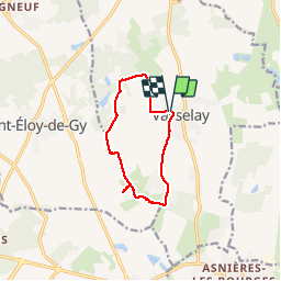

Length
9.5 km

Max alt
189 m

Uphill gradient
70 m
Km-Effort
10.4 km

Min alt
149 m

Downhill gradient
71 m
Boucle
Yes
Creation date :
2016-04-22 00:00:00.0
Updated on :
2016-04-22 00:00:00.0
2h18
Difficulty : Medium

FREE GPS app for hiking
 SityTrail
IGN / Geographical institutes
SityTrail Plus
The world is yours!
About
Trail Walking of 9.5 km to be discovered at Centre-Loire Valley, Cher, Vasselay. This trail is proposed by jlrayon.
Description
Balade de d’une dizaine de kilomètres aux alentours de Vasselay.
Positioning
Country:
France
Region :
Centre-Loire Valley
Department/Province :
Cher
Municipality :
Vasselay
Location:
Unknown
Start:(Dec)
Start:(UTM)
453406 ; 5222925 (31T) N.
Comments