Trail Other activity Sainte-Croix - Les Montagnes de Baulnes  - Photo
 Mecki
Mecki

User

© OpenStreetMap contributors
Length
Length
5.5 km
Max alt
Max alt
1535 m
Uphill gradient
Uphill gradient
324 m
Km-Effort
Km-Effort  
9.2 km
Min alt
Min alt
1235 m
Downhill gradient
Downhill gradient
138 m
Boucle
Boucle
No
Creation date :
2016-04-26 00:00:00.0
Updated on :
2016-04-26 00:00:00.0

(0 Reviews)

Other activity
Other activity
1h44
Difficulty : Unknown

Scan this QR Code to open this trail in the SityTrail application

FREE GPS app for hiking

Logo SityTrail SityTrail

IGN / Geographical institutes

Download SityTrail from the App Store Download SityTrail from Google Play

Logo SityTrail SityTrail World

The world is yours!

Download SityTrail from the App Store Download SityTrail from Google Play Download SityTrail on Huawei AppGallery

About

Trail Other activity of 5.5 km to be discovered at Vaud, District du Jura-Nord vaudois, Sainte-Croix. This trail is proposed by Mecki.

Elevation profile

Photos

Positioning

Country:
Switzerland
Region :
Vaud
Department/Province :
District du Jura-Nord vaudois
Municipality :
Sainte-Croix
Location:
Unknown
Start:(UTM)
307510 ; 5186889 (32T) N.

Trails nearby

Trail On foot Sainte-Croix - La Gittaz-Col de l'Aigullon - Photo
On foot
PRO

On foot

Easy
Sainte-Croix, Vaud, District du Jura-Nord vaudois, Switzerland
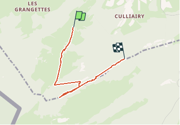
4.1 km | 6.4 km-effort
1h 26min
No
Trail On foot Sainte-Croix - Sainte Croix-La Gittaz - Photo
On foot
PRO

On foot

Easy
Sainte-Croix, Vaud, District du Jura-Nord vaudois, Switzerland
5.7 km | 8.3 km-effort
1h 53min
No
Trail On foot Sainte-Croix - Chemin de la Gare - Photo
On foot
PRO

On foot

Easy
Sainte-Croix, Vaud, District du Jura-Nord vaudois, Switzerland
6.5 km | 8.6 km-effort
1h 57min
No
Trail Walking Jougne - Aiguilles de Baulmes - Suisse - Photo
Walking
albert39

Walking

Difficult
(1)
Jougne, Bourgogne-Franche-Comté, Doubs, France
16.4 km | 26 km-effort
5h 33min
Yes
Trail Cross-country skiing Les Fourgs - Piste du Voirnon - Photo
Cross-country skiing
mallovon

Cross-country skiing

Easy
Les Fourgs, Bourgogne-Franche-Comté, Doubs, France
11.8 km | 15.2 km-effort
3h 39min
Yes
Trail On foot Les Fourgs - Le Sentier des Bornes - Photo
On foot
PRO

On foot

Easy
Les Fourgs, Bourgogne-Franche-Comté, Doubs, France
6.4 km | 8 km-effort
1h 48min
No
Trail Walking Sainte-Croix - le Chasseron par les avattes - Photo
Walking
viam19

Walking

Medium
Sainte-Croix, Vaud, District du Jura-Nord vaudois, Switzerland
13.3 km | 20 km-effort
4h 18min
Yes
Trail Walking Jougne - aiguilles de Baulmes et retour  Suchet  - Photo
Walking
BM25

Walking

Very easy
Jougne, Bourgogne-Franche-Comté, Doubs, France
23 km | 37 km-effort
6h 31min
Yes
Trail Snowshoes Sainte-Croix - Col des Etroits Le Chasseron CAF - Photo
Snowshoes
TRIMAILLE

Snowshoes

Difficult
Sainte-Croix, Vaud, District du Jura-Nord vaudois, Switzerland
12.2 km | 19.9 km-effort
Unknown
Yes


Close
My subscriptions