


Ardèche 4 Salavas

jcm17
User
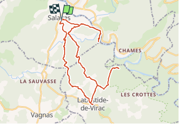

Length
22 km

Max alt
369 m

Uphill gradient
625 m
Km-Effort
30 km

Min alt
79 m

Downhill gradient
631 m
Boucle
Yes
Creation date :
2016-04-29 00:00:00.0
Updated on :
2016-04-29 00:00:00.0
6h21
Difficulty : Difficult

FREE GPS app for hiking
 SityTrail
IGN / Geographical institutes
SityTrail Plus
The world is yours!
About
Trail Walking of 22 km to be discovered at Auvergne-Rhône-Alpes, Ardèche, Salavas. This trail is proposed by jcm17.
Positioning
Country:
France
Region :
Auvergne-Rhône-Alpes
Department/Province :
Ardèche
Municipality :
Salavas
Location:
Unknown
Start:(Dec)
Start:(UTM)
609916 ; 4916449 (31T) N.
Comments