


Trail 22 nuit de mai Stavelot

Nico222
User
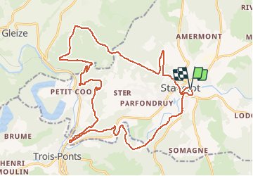

Length
22 km

Max alt
505 m

Uphill gradient
921 m
Km-Effort
34 km

Min alt
252 m

Downhill gradient
921 m
Boucle
Yes
Creation date :
2016-05-01 00:00:00.0
Updated on :
2016-05-01 00:00:00.0
2h00
Difficulty : Very difficult

FREE GPS app for hiking
 SityTrail
IGN / Geographical institutes
SityTrail Plus
The world is yours!
About
Trail Running of 22 km to be discovered at Wallonia, Liège, Stavelot. This trail is proposed by Nico222.
Description
Parcours 2016 du trail de 22 km de la nuit de mai.
Positioning
Country:
Belgium
Region :
Wallonia
Department/Province :
Liège
Municipality :
Stavelot
Location:
Stavelot
Start:(Dec)
Start:(UTM)
708666 ; 5586490 (31U) N.
Comments