


04.05.2016 - CAMPEL Nord et Est

babeth35
User
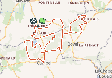

Length
28 km

Max alt
139 m

Uphill gradient
366 m
Km-Effort
33 km

Min alt
79 m

Downhill gradient
365 m
Boucle
Yes
Creation date :
2016-05-04 00:00:00.0
Updated on :
2020-07-20 15:33:08.551
6h25
Difficulty : Medium

FREE GPS app for hiking
 SityTrail
IGN / Geographical institutes
SityTrail Plus
The world is yours!
About
Trail Walking of 28 km to be discovered at Brittany, Ille-et-Vilaine, Maxent. This trail is proposed by babeth35.
Positioning
Country:
France
Region :
Brittany
Department/Province :
Ille-et-Vilaine
Municipality :
Maxent
Location:
Unknown
Start:(Dec)
Start:(UTM)
573470 ; 5312586 (30T) N.
Comments