


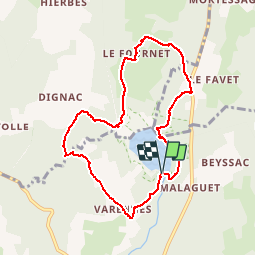
Autour du Lac de Malaguet

Fky78
User

Length
8.5 km

Max alt
1094 m

Uphill gradient
171 m
Km-Effort
10.7 km

Min alt
1020 m

Downhill gradient
169 m
Boucle
Yes
Creation date :
2016-05-05 00:00:00.0
Updated on :
2016-05-05 00:00:00.0
2h35
Difficulty : Easy

FREE GPS app for hiking
 SityTrail
IGN / Geographical institutes
SityTrail Plus
The world is yours!
About
Trail Walking of 8.5 km to be discovered at Auvergne-Rhône-Alpes, Haute-Loire, Monlet. This trail is proposed by Fky78.
Positioning
Country:
France
Region :
Auvergne-Rhône-Alpes
Department/Province :
Haute-Loire
Municipality :
Monlet
Location:
Unknown
Start:(Dec)
Start:(UTM)
556068 ; 5010728 (31T) N.
Comments