


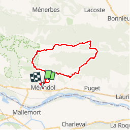
merindol forêt de cèdre s

mesrandos
User


7h40
Difficulty : Difficult

FREE GPS app for hiking
 SityTrail
IGN / Geographical institutes
SityTrail Plus
The world is yours!
About
Trail Walking of 28 km to be discovered at Provence-Alpes-Côte d'Azur, Vaucluse, Mérindol. This trail is proposed by mesrandos.
Description
très jolie parcours, jolies sentiers, très belles vues. juste un bout de route au niveau du massif des cèdres. tres jolie sentier sous la barre rocheuse du roque des bancs. attention la descente après le sommet du vallon bernard est très pentue et glissante. il vaut mieux revenir sur le gr. classer en niveau difficile pour la longueur, sinon aucune difficulté sur ce parcours
Positioning
Comments