


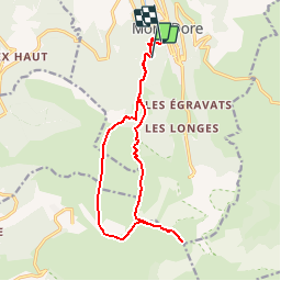
Ascension du Sancy - 15 km - 5h00

Bastet
User

Length
14.9 km

Max alt
1859 m

Uphill gradient
689 m
Km-Effort
25 km

Min alt
1060 m

Downhill gradient
867 m
Boucle
No
Creation date :
2018-05-14 00:00:00.0
Updated on :
2018-05-14 00:00:00.0
4h57
Difficulty : Difficult

FREE GPS app for hiking
 SityTrail
IGN / Geographical institutes
SityTrail Plus
The world is yours!
About
Trail Walking of 14.9 km to be discovered at Auvergne-Rhône-Alpes, Puy-de-Dôme, Mont-Dore. This trail is proposed by Bastet.
Positioning
Country:
France
Region :
Auvergne-Rhône-Alpes
Department/Province :
Puy-de-Dôme
Municipality :
Mont-Dore
Location:
Unknown
Start:(Dec)
Start:(UTM)
484758 ; 5046133 (31T) N.
Comments