


DIOIS 3J J1 1605

azipat
User
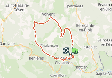

Length
36 km

Max alt
1418 m

Uphill gradient
1463 m
Km-Effort
55 km

Min alt
545 m

Downhill gradient
1449 m
Boucle
Yes
Creation date :
2016-05-12 00:00:00.0
Updated on :
2016-05-12 00:00:00.0
6h45
Difficulty : Medium

FREE GPS app for hiking
 SityTrail
IGN / Geographical institutes
SityTrail Plus
The world is yours!
About
Trail Equestrian of 36 km to be discovered at Auvergne-Rhône-Alpes, Drôme, La Motte-Chalancon. This trail is proposed by azipat.
Positioning
Country:
France
Region :
Auvergne-Rhône-Alpes
Department/Province :
Drôme
Municipality :
La Motte-Chalancon
Location:
Unknown
Start:(Dec)
Start:(UTM)
690420 ; 4929032 (31T) N.
Comments