Peyrelade

ARPF
User

Length
9.1 km

Max alt
841 m

Uphill gradient
400 m
Km-Effort
14.4 km

Min alt
484 m

Downhill gradient
410 m
Boucle
Yes
Creation date :
2016-05-12 00:00:00.0
Updated on :
2016-05-12 00:00:00.0
3h00
Difficulty : Unknown

FREE GPS app for hiking
 SityTrail
IGN / Geographical institutes
SityTrail Plus
The world is yours!
About
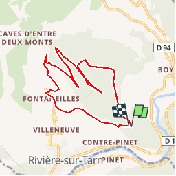
Trail Walking of 9.1 km to be discovered at Occitania, Aveyron, Rivière-sur-Tarn. This trail is proposed by ARPF.
Description
Peyrelade et le Puech de Fontaneilles
Positioning
Country:
France
Region :
Occitania
Department/Province :
Aveyron
Municipality :
Rivière-sur-Tarn
Location:
Unknown
Start:(Dec)
Start:(UTM)
511893 ; 4893479 (31T) N.
Comments