


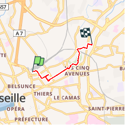
Marseille St Charles -les Chartreux

ARPF
User

Length
3 km

Max alt
76 m

Uphill gradient
46 m
Km-Effort
3.6 km

Min alt
36 m

Downhill gradient
48 m
Boucle
No
Creation date :
2016-05-13 00:00:00.0
Updated on :
2016-05-13 00:00:00.0
1h00
Difficulty : Unknown

FREE GPS app for hiking
 SityTrail
IGN / Geographical institutes
SityTrail Plus
The world is yours!
About
Trail Walking of 3 km to be discovered at Provence-Alpes-Côte d'Azur, Bouches-du-Rhône, Marseille. This trail is proposed by ARPF.
Description
Marseille 4ème arrondissement .
Gare St Charles à l'Eglise des Chartreux en passant par le Palais Longchamp.
Positioning
Country:
France
Region :
Provence-Alpes-Côte d'Azur
Department/Province :
Bouches-du-Rhône
Municipality :
Marseille
Location:
1st Arrondissement
Start:(Dec)
Start:(UTM)
693123 ; 4797191 (31T) N.
Comments