


Eiffage de Millau 2016

loic09
User

Length
23 km

Max alt
614 m

Uphill gradient
946 m
Km-Effort
36 km

Min alt
343 m

Downhill gradient
928 m
Boucle
No
Creation date :
2016-05-17 00:00:00.0
Updated on :
2016-05-17 00:00:00.0
2h00
Difficulty : Medium

FREE GPS app for hiking
 SityTrail
IGN / Geographical institutes
SityTrail Plus
The world is yours!
About
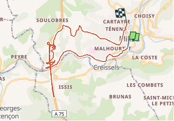
Trail Running of 23 km to be discovered at Occitania, Aveyron, Millau. This trail is proposed by loic09.
Description
Course Eiffage de Millau
Positioning
Country:
France
Region :
Occitania
Department/Province :
Aveyron
Municipality :
Millau
Location:
Unknown
Start:(Dec)
Start:(UTM)
506135 ; 4882560 (31T) N.
Comments