


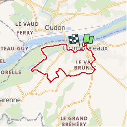
champtoceaux

funkady
User

Length
12 km

Max alt
85 m

Uphill gradient
117 m
Km-Effort
13.6 km

Min alt
4 m

Downhill gradient
117 m
Boucle
Yes
Creation date :
2016-05-16 00:00:00.0
Updated on :
2016-05-16 00:00:00.0
1h15
Difficulty : Easy

FREE GPS app for hiking
 SityTrail
IGN / Geographical institutes
SityTrail Plus
The world is yours!
About
Trail Running of 12 km to be discovered at Pays de la Loire, Maine-et-Loire, Orée-d'Anjou. This trail is proposed by funkady.
Positioning
Country:
France
Region :
Pays de la Loire
Department/Province :
Maine-et-Loire
Municipality :
Orée-d'Anjou
Location:
Champtoceaux
Start:(Dec)
Start:(UTM)
630876 ; 5243954 (30T) N.
Comments