


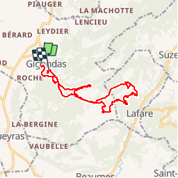
Gigondas Dentelle de Montmirail2 Montée cascade

GrouGary
User


6h06
Difficulty : Medium

FREE GPS app for hiking
 SityTrail
IGN / Geographical institutes
SityTrail Plus
The world is yours!
About
Trail Walking of 16.9 km to be discovered at Provence-Alpes-Côte d'Azur, Vaucluse, Gigondas. This trail is proposed by GrouGary.
Description
1ère partie facile, bien balisée, sans risque aux pieds des Dentelles. 2ème partie plus sauvage, qui demande de la vigilance pour suivre le sentier balisé en points bleu. Balisage fréquent. Très beau circuit sans difficultés
Couac de mon GPS qd la batterie faiblit (près de la cascade)
Positioning
Comments