


Dentelles de Montmirail - Chapelle St Christophe - Cayron

Nathy8913
User
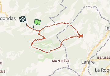

Length
12.5 km

Max alt
584 m

Uphill gradient
498 m
Km-Effort
19.3 km

Min alt
255 m

Downhill gradient
554 m
Boucle
No
Creation date :
2016-05-17 00:00:00.0
Updated on :
2016-05-17 00:00:00.0
4h45
Difficulty : Medium

FREE GPS app for hiking
 SityTrail
IGN / Geographical institutes
SityTrail Plus
The world is yours!
About
Trail Walking of 12.5 km to be discovered at Provence-Alpes-Côte d'Azur, Vaucluse, Gigondas. This trail is proposed by Nathy8913.
Positioning
Country:
France
Region :
Provence-Alpes-Côte d'Azur
Department/Province :
Vaucluse
Municipality :
Gigondas
Location:
Unknown
Start:(Dec)
Start:(UTM)
661585 ; 4891591 (31T) N.
Comments