J3 St Jean des Balmes Ermitage St Michel

ARPF
User
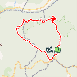

Length
9.6 km

Max alt
903 m

Uphill gradient
323 m
Km-Effort
13.9 km

Min alt
677 m

Downhill gradient
319 m
Boucle
Yes
Creation date :
2016-06-09 00:00:00.0
Updated on :
2016-06-09 00:00:00.0
3h18
Difficulty : Easy

FREE GPS app for hiking
 SityTrail
IGN / Geographical institutes
SityTrail Plus
The world is yours!
About
Trail Walking of 9.6 km to be discovered at Occitania, Aveyron, Veyreau. This trail is proposed by ARPF.
Description
P2 T2 Belle rando, facile, sur le plateau du Cause Noir. Très belle vue sut les Gorges de la Jonte.
Passages étroits au bord des Gorges de la Jonte.
Positioning
Country:
France
Region :
Occitania
Department/Province :
Aveyron
Municipality :
Veyreau
Location:
Unknown
Start:(Dec)
Start:(UTM)
519597 ; 4890994 (31T) N.
Comments