


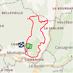
J2 Liaucous-Vors-St Marcellin-Eglazines

ARPF
User

Length
15.7 km

Max alt
948 m

Uphill gradient
735 m
Km-Effort
25 km

Min alt
471 m

Downhill gradient
727 m
Boucle
Yes
Creation date :
2016-06-09 00:00:00.0
Updated on :
2016-06-09 00:00:00.0
5h29
Difficulty : Difficult

FREE GPS app for hiking
 SityTrail
IGN / Geographical institutes
SityTrail Plus
The world is yours!
About
Trail Walking of 15.7 km to be discovered at Occitania, Aveyron, Mostuéjouls. This trail is proposed by ARPF.
Description
P2 T2 Très belles vues sur les Gorges du Tarn, plus Cirque de St Marcellin et habitation semi troglodytique à Eglazines, puis retour à Liaucous
Positioning
Country:
France
Region :
Occitania
Department/Province :
Aveyron
Municipality :
Mostuéjouls
Location:
Unknown
Start:(Dec)
Start:(UTM)
515526 ; 4894394 (31T) N.
Comments