Trail Walking Saint-Jean-en-Royans - Tour de l'echarasson avec description - Photo

Tour de l'echarasson avec description

 bob2023
bob2023

User

© OpenStreetMap contributors
Length
Length
9.9 km
Max alt
Max alt
1159 m
Uphill gradient
Uphill gradient
525 m
Km-Effort
Km-Effort  
16.9 km
Min alt
Min alt
822 m
Downhill gradient
Downhill gradient
520 m
Boucle
Boucle
Yes
Creation date :
2018-08-26 08:32:15.163
Updated on :
2018-08-26 08:32:15.171

(0 Reviews)

Walking
Walking
3h27
Difficulty : Easy

Scan this QR Code to open this trail in the SityTrail application

FREE GPS app for hiking

Logo SityTrail SityTrail

IGN / Geographical institutes

Download SityTrail from the App Store Download SityTrail from Google Play

Logo SityTrail SityTrail Plus

The world is yours!

Download SityTrail from the App Store Download SityTrail from Google Play Download SityTrail on Huawei AppGallery

About

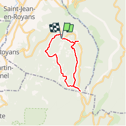
Trail Walking of 9.9 km to be discovered at Auvergne-Rhône-Alpes, Drôme, Saint-Jean-en-Royans. This trail is proposed by bob2023.

Description

Très jolie randonnée qui permettra d'avoir de belles vues sur Combe laval. Un petit détour permettra de voir le col de la Machine et la vue imposante sur les Grands Goulets (attention pas de marquage, et une bonne descente).
Cette randonnée vous fera découvrir les différentes essences d'arbres du vercors.
Parfois le trajet ne suis pas vraiment la carte IGN, il faut bien suivre le balisage jaune et vert.
Cette randonnée ne presente aucune difficulté majeure.

Elevation profile

Positioning

Country:
France
Region :
Auvergne-Rhône-Alpes
Department/Province :
Drôme
Municipality :
Saint-Jean-en-Royans
Location:
Unknown
Start:(UTM)
682884 ; 4985915 (31T) N.


Close
My subscriptions