


tavers

murph
User
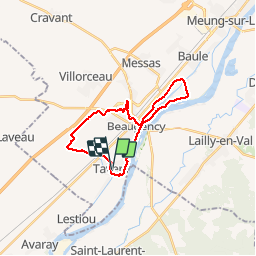

Length
22 km

Max alt
113 m

Uphill gradient
141 m
Km-Effort
24 km

Min alt
79 m

Downhill gradient
140 m
Boucle
Yes
Creation date :
2016-05-22 00:00:00.0
Updated on :
2019-12-22 15:27:48.363
4h45
Difficulty : Unknown

FREE GPS app for hiking
 SityTrail
IGN / Geographical institutes
SityTrail Plus
The world is yours!
About
Trail Other activity of 22 km to be discovered at Centre-Loire Valley, Loiret, Tavers. This trail is proposed by murph.
Positioning
Country:
France
Region :
Centre-Loire Valley
Department/Province :
Loiret
Municipality :
Tavers
Location:
Unknown
Start:(Dec)
Start:(UTM)
396217 ; 5290243 (31T) N.
Comments