


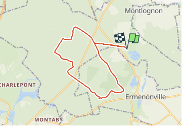
abaye de Chaaly

LaurentBernard
User

Length
15 km

Max alt
127 m

Uphill gradient
169 m
Km-Effort
17.2 km

Min alt
70 m

Downhill gradient
169 m
Boucle
Yes
Creation date :
2017-11-09 00:00:00.0
Updated on :
2017-11-09 00:00:00.0
3h46
Difficulty : Medium

FREE GPS app for hiking
 SityTrail
IGN / Geographical institutes
SityTrail Plus
The world is yours!
About
Trail Walking of 15 km to be discovered at Hauts-de-France, Oise, Fontaine-Chaalis. This trail is proposed by LaurentBernard.
Positioning
Country:
France
Region :
Hauts-de-France
Department/Province :
Oise
Municipality :
Fontaine-Chaalis
Location:
Unknown
Start:(Dec)
Start:(UTM)
476887 ; 5443840 (31U) N.
Comments