


29.05.2016 - CAMARET

babeth35
User

Length
25 km

Max alt
60 m

Uphill gradient
454 m
Km-Effort
32 km

Min alt
-2 m

Downhill gradient
467 m
Boucle
Yes
Creation date :
2016-05-29 00:00:00.0
Updated on :
2020-07-20 15:32:29.186
7h31
Difficulty : Difficult

FREE GPS app for hiking
 SityTrail
IGN / Geographical institutes
SityTrail Plus
The world is yours!
About
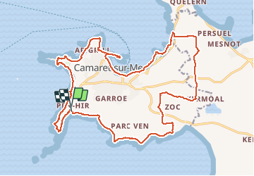
Trail Walking of 25 km to be discovered at Brittany, Finistère, Camaret-sur-Mer. This trail is proposed by babeth35.
Positioning
Country:
France
Region :
Brittany
Department/Province :
Finistère
Municipality :
Camaret-sur-Mer
Location:
Unknown
Start:(Dec)
Start:(UTM)
380079 ; 5346810 (30U) N.
Comments