


2014 Maroc

rousseau.mich
User
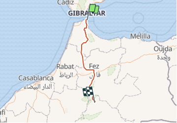

Length
426 km

Max alt
2281 m

Uphill gradient
13312 m
Km-Effort
599 km

Min alt
-3 m

Downhill gradient
11861 m
Boucle
No
Creation date :
2016-05-30 00:00:00.0
Updated on :
2016-05-30 00:00:00.0
83h20
Difficulty : Unknown

FREE GPS app for hiking
 SityTrail
IGN / Geographical institutes
SityTrail Plus
The world is yours!
About
Trail Other activity of 426 km to be discovered at Ceuta, Unknown, Ceuta. This trail is proposed by rousseau.mich.
Positioning
Country:
Spain
Region :
Ceuta
Department/Province :
Unknown
Municipality :
Ceuta
Location:
Unknown
Start:(Dec)
Start:(UTM)
291009 ; 3974157 (30S) N.
Comments