


2016-06-12 Laffrey - Corps

Lucquiaud
User
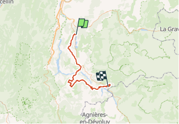

Length
65 km

Max alt
1266 m

Uphill gradient
1565 m
Km-Effort
85 km

Min alt
542 m

Downhill gradient
1241 m
Boucle
No
Creation date :
2018-09-15 15:05:19.969
Updated on :
2018-09-15 15:05:21.099
4h47
Difficulty : Difficult

FREE GPS app for hiking
 SityTrail
IGN / Geographical institutes
SityTrail Plus
The world is yours!
About
Trail Cycle of 65 km to be discovered at Auvergne-Rhône-Alpes, Isère, Laffrey. This trail is proposed by Lucquiaud.
Positioning
Country:
France
Region :
Auvergne-Rhône-Alpes
Department/Province :
Isère
Municipality :
Laffrey
Location:
Unknown
Start:(Dec)
Start:(UTM)
719115 ; 4989388 (31T) N.
Comments