


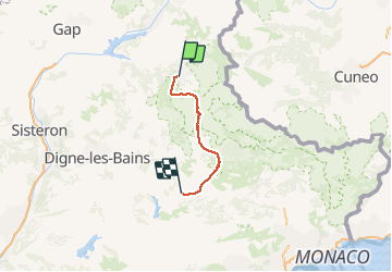
2016-06-16 Barcelonnette - Annot 89km

Lucquiaud
User

Length
89 km

Max alt
2331 m

Uphill gradient
2314 m
Km-Effort
121 km

Min alt
534 m

Downhill gradient
2766 m
Boucle
No
Creation date :
2018-09-15 15:05:14.19
Updated on :
2018-09-15 15:05:14.245
6h30
Difficulty : Difficult

FREE GPS app for hiking
 SityTrail
IGN / Geographical institutes
SityTrail Plus
The world is yours!
About
Trail Cycle of 89 km to be discovered at Provence-Alpes-Côte d'Azur, Alpes-de-Haute-Provence, Barcelonnette. This trail is proposed by Lucquiaud.
Positioning
Country:
France
Region :
Provence-Alpes-Côte d'Azur
Department/Province :
Alpes-de-Haute-Provence
Municipality :
Barcelonnette
Location:
Unknown
Start:(Dec)
Start:(UTM)
312998 ; 4917562 (32T) N.
Comments