


MontBlanc_vallorcine_refuge de berard par cascade

m261212
User
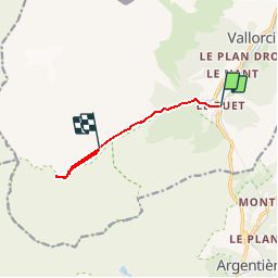

Length
6.3 km

Max alt
1938 m

Uphill gradient
595 m
Km-Effort
13 km

Min alt
1344 m

Downhill gradient
210 m
Boucle
No
Creation date :
2017-08-26 00:00:00.0
Updated on :
2017-08-26 00:00:00.0
2h58
Difficulty : Medium

FREE GPS app for hiking
 SityTrail
IGN / Geographical institutes
SityTrail Plus
The world is yours!
About
Trail Walking of 6.3 km to be discovered at Auvergne-Rhône-Alpes, Upper Savoy, Vallorcine. This trail is proposed by m261212.
Positioning
Country:
France
Region :
Auvergne-Rhône-Alpes
Department/Province :
Upper Savoy
Municipality :
Vallorcine
Location:
Unknown
Start:(Dec)
Start:(UTM)
338996 ; 5098239 (32T) N.
Comments