


MontBlanc_les houches_aiguillettest

m261212
User
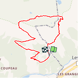

Length
9.9 km

Max alt
2276 m

Uphill gradient
932 m
Km-Effort
22 km

Min alt
1378 m

Downhill gradient
947 m
Boucle
Yes
Creation date :
2017-08-26 00:00:00.0
Updated on :
2017-08-26 00:00:00.0
4h30
Difficulty : Medium

FREE GPS app for hiking
 SityTrail
IGN / Geographical institutes
SityTrail Plus
The world is yours!
About
Trail Walking of 9.9 km to be discovered at Auvergne-Rhône-Alpes, Upper Savoy, Les Houches. This trail is proposed by m261212.
Positioning
Country:
France
Region :
Auvergne-Rhône-Alpes
Department/Province :
Upper Savoy
Municipality :
Les Houches
Location:
Unknown
Start:(Dec)
Start:(UTM)
331074 ; 5086101 (32T) N.
Comments