


Strasbourg Impérial

phil88
User
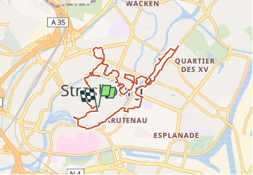

Length
11.6 km

Max alt
159 m

Uphill gradient
122 m
Km-Effort
13.2 km

Min alt
134 m

Downhill gradient
116 m
Boucle
Yes
Creation date :
2016-06-06 00:00:00.0
Updated on :
2016-06-06 00:00:00.0
3h40
Difficulty : Easy

FREE GPS app for hiking
 SityTrail
IGN / Geographical institutes
SityTrail Plus
The world is yours!
About
Trail Walking of 11.6 km to be discovered at Grand Est, Bas-Rhin, Strasbourg. This trail is proposed by phil88.
Description
Ballade en ville
Photos


71 photos in total. Please click on a photo to see them all in the gallery.
Points of interest


Positioning
Country:
France
Region :
Grand Est
Department/Province :
Bas-Rhin
Municipality :
Strasbourg
Location:
Unknown
Start:(Dec)
Start:(UTM)
407807 ; 5381728 (32U) N.
Comments