


verticale du diable

mikaelerouzic
User
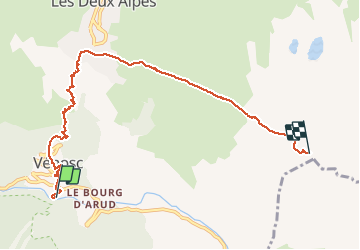

Length
7.7 km

Max alt
2775 m

Uphill gradient
1841 m
Km-Effort
26 km

Min alt
930 m

Downhill gradient
3 m
Boucle
No
Creation date :
2016-06-07 00:00:00.0
Updated on :
2016-06-07 00:00:00.0
1h30
Difficulty : Very difficult

FREE GPS app for hiking
 SityTrail
IGN / Geographical institutes
SityTrail Plus
The world is yours!
About
Trail Running of 7.7 km to be discovered at Auvergne-Rhône-Alpes, Isère, Les Deux Alpes. This trail is proposed by mikaelerouzic.
Description
double KV
Positioning
Country:
France
Region :
Auvergne-Rhône-Alpes
Department/Province :
Isère
Municipality :
Les Deux Alpes
Location:
Vénosc
Start:(Dec)
Start:(UTM)
272625 ; 4985443 (32T) N.
Comments