


mongresin

daniel77
User
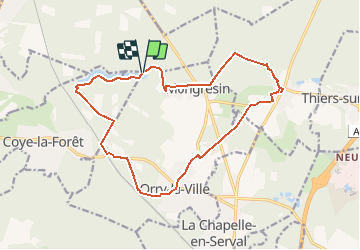

Length
16 km

Max alt
100 m

Uphill gradient
175 m
Km-Effort
18.4 km

Min alt
48 m

Downhill gradient
175 m
Boucle
Yes
Creation date :
2016-06-14 00:00:00.0
Updated on :
2016-06-14 00:00:00.0
4h00
Difficulty : Easy

FREE GPS app for hiking
 SityTrail
IGN / Geographical institutes
SityTrail Plus
The world is yours!
About
Trail Walking of 16 km to be discovered at Hauts-de-France, Oise, Orry-la-Ville. This trail is proposed by daniel77.
Positioning
Country:
France
Region :
Hauts-de-France
Department/Province :
Oise
Municipality :
Orry-la-Ville
Location:
Unknown
Start:(Dec)
Start:(UTM)
463652 ; 5445156 (31U) N.
Comments