


Clot du puy

markford
User
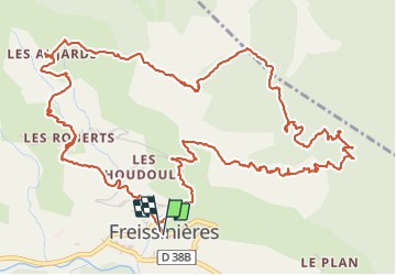

Length
9.6 km

Max alt
1759 m

Uphill gradient
662 m
Km-Effort
18.4 km

Min alt
1203 m

Downhill gradient
654 m
Boucle
Yes
Creation date :
2016-06-15 00:00:00.0
Updated on :
2016-06-15 00:00:00.0
3h58
Difficulty : Difficult

FREE GPS app for hiking
 SityTrail
IGN / Geographical institutes
SityTrail Plus
The world is yours!
About
Trail Walking of 9.6 km to be discovered at Provence-Alpes-Côte d'Azur, Hautes-Alpes, Freissinières. This trail is proposed by markford.
Description
Vue panoramique sur le val du Durance. Decent un peu technique sur le sentier du falaise.
panoramic view of the durance valley. the decent of the on the cliff path a little technical.


Positioning
Country:
France
Region :
Provence-Alpes-Côte d'Azur
Department/Province :
Hautes-Alpes
Municipality :
Freissinières
Location:
Unknown
Start:(Dec)
Start:(UTM)
305099 ; 4958516 (32T) N.
Comments