


le rocher garaux

bymarc26
User
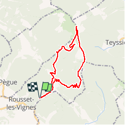

Length
17.1 km

Max alt
1327 m

Uphill gradient
908 m
Km-Effort
29 km

Min alt
461 m

Downhill gradient
907 m
Boucle
Yes
Creation date :
2016-06-16 00:00:00.0
Updated on :
2016-06-16 00:00:00.0
7h00
Difficulty : Medium

FREE GPS app for hiking
 SityTrail
IGN / Geographical institutes
SityTrail Plus
The world is yours!
About
Trail Walking of 17.1 km to be discovered at Auvergne-Rhône-Alpes, Drôme, Rousset-les-Vignes. This trail is proposed by bymarc26.
Description
depuis les guilles
Positioning
Country:
France
Region :
Auvergne-Rhône-Alpes
Department/Province :
Drôme
Municipality :
Rousset-les-Vignes
Location:
Unknown
Start:(Dec)
Start:(UTM)
665202 ; 4920804 (31T) N.
Comments
ok