


klingenthal-rottlach

XavierFaidix
User
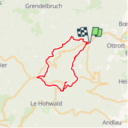

Length
23 km

Max alt
962 m

Uphill gradient
770 m
Km-Effort
33 km

Min alt
341 m

Downhill gradient
769 m
Boucle
Yes
Creation date :
2019-04-01 20:34:44.66
Updated on :
2019-04-01 20:34:44.729
3h10
Difficulty : Medium

FREE GPS app for hiking
 SityTrail
IGN / Geographical institutes
SityTrail Plus
The world is yours!
About
Trail Mountain bike of 23 km to be discovered at Grand Est, Bas-Rhin, Ottrott. This trail is proposed by XavierFaidix.
Description
délicieux parcours préparé par sophie
Positioning
Country:
France
Region :
Grand Est
Department/Province :
Bas-Rhin
Municipality :
Ottrott
Location:
Unknown
Start:(Dec)
Start:(UTM)
380767 ; 5368596 (32U) N.
Comments