


montée d'Oz

mikaelerouzic
User
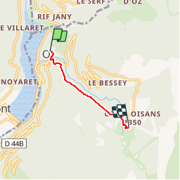

Length
2.7 km

Max alt
1352 m

Uphill gradient
485 m
Km-Effort
7.6 km

Min alt
859 m

Downhill gradient
2 m
Boucle
No
Creation date :
2016-06-22 00:00:00.0
Updated on :
2016-06-22 00:00:00.0
27m
Difficulty : Difficult

FREE GPS app for hiking
 SityTrail
IGN / Geographical institutes
SityTrail Plus
The world is yours!
About
Trail Running of 2.7 km to be discovered at Auvergne-Rhône-Alpes, Isère, Oz. This trail is proposed by mikaelerouzic.
Positioning
Country:
France
Region :
Auvergne-Rhône-Alpes
Department/Province :
Isère
Municipality :
Oz
Location:
Unknown
Start:(Dec)
Start:(UTM)
268231 ; 5002836 (32T) N.
Comments