Trail Walking Nendaz - lac Cleuson - cabane St Laurent - Photo

lac Cleuson - cabane St Laurent

© OpenStreetMap contributors
Length
Length
19.3 km
Max alt
Max alt
2505 m
Uphill gradient
Uphill gradient
933 m
Km-Effort
Km-Effort  
32 km
Min alt
Min alt
1727 m
Downhill gradient
Downhill gradient
938 m
Boucle
Boucle
Yes
Creation date :
2016-06-23 00:00:00.0
Updated on :
2016-06-23 00:00:00.0

(2 Reviews)

Walking
Walking
6h37
Difficulty : Medium

Scan this QR Code to open this trail in the SityTrail application

FREE GPS app for hiking

Logo SityTrail SityTrail

IGN / Geographical institutes

Download SityTrail from the App Store Download SityTrail from Google Play

Logo SityTrail SityTrail World

The world is yours!

Download SityTrail from the App Store Download SityTrail from Google Play Download SityTrail on Huawei AppGallery

About

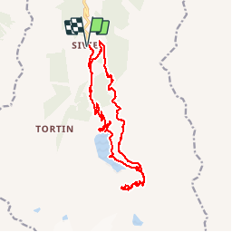
Trail Walking of 19.3 km to be discovered at Valais/Wallis, Conthey, Nendaz. This trail is proposed by dalla.anthony.

Description

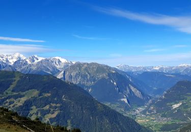
Randonnée au lac Cleuson jusqu'à la cabane St Laurent en partant de la station de ski de Siviez.
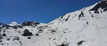
Je comptais monter jusqu'au lac du grand désert mais il y avait encore trop de neige le 23/06/2016, le chemin étant exposé nord et vu la quantité de neige qu'il y avait je ne pense pas que le lac sera accessible avant mi juillet sans mettre les pieds dans la neige.

Elevation profile

Photos

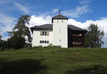
26 photos in total. Please click on a photo to see them all in the gallery.

Points of interest

Point of interest Nendaz - neige - Photo
dalla.anthony
NENDAZ 

Positioning

Country:
Switzerland
Region :
Valais/Wallis
Department/Province :
Conthey
Municipality :
Nendaz
Location:
Unknown
Start:(UTM)
369965 ; 5110448 (32T) N.

Comments

Please log in to post a review or rate the element


Trails nearby

Trail On foot Isérables - Balavaux - fixme - Photo
On foot
PRO

On foot

Easy
Isérables, Valais/Wallis, Martigny, Switzerland
3.9 km | 6.8 km-effort
1h 33min
No
Trail On foot Nendaz - Mayens-de-Sion ouest - Planchouet - Photo
On foot
PRO

On foot

Easy
Nendaz, Valais/Wallis, Conthey, Switzerland
10.1 km | 13.2 km-effort
2h 59min
No
Trail Walking Val de Bagnes - Le Châble – Cabane de Louvie / Jour 2 - Photo
Walking
Greg813

Walking

Difficult
Val de Bagnes, Valais/Wallis, Entremont, Switzerland
12.4 km | 21 km-effort
3h 37min
No
Trail On foot Isérables - Le Rosey - Taillay - Photo
On foot
PRO

On foot

Easy
Isérables, Valais/Wallis, Martigny, Switzerland
4.4 km | 5.7 km-effort
1h 18min
No
Trail Walking Nendaz - vs_hike666c - Photo
Walking
GUIDE+

Walking

Very easy
Nendaz, Valais/Wallis, Conthey, Switzerland
13.4 km | 18.6 km-effort
3h 27min
No
Trail Walking Nendaz - vs_hike666b - Photo
Walking
GUIDE+

Walking

Very easy
Nendaz, Valais/Wallis, Conthey, Switzerland
10.6 km | 15.4 km-effort
2h 53min
No
Trail Walking Nendaz - vs_hike666a - Photo
Walking
GUIDE+

Walking

Very easy
Nendaz, Valais/Wallis, Conthey, Switzerland
6 km | 7.6 km-effort
1h 31min
No
Trail Walking Val de Bagnes - vs_hike680d - Photo
Walking
GUIDE+

Walking

Very easy
Val de Bagnes, Valais/Wallis, Entremont, Switzerland
14.3 km | 25 km-effort
4h 22min
No
Trail Mountain bike Nendaz - Tour du MontFort - easy - Photo
Mountain bike
GUIDE+

Mountain bike

Very easy
Nendaz, Valais/Wallis, Conthey, Switzerland
48 km | 84 km-effort
Unknown
Yes


Close
My subscriptions