


xxx

sandra54570
User
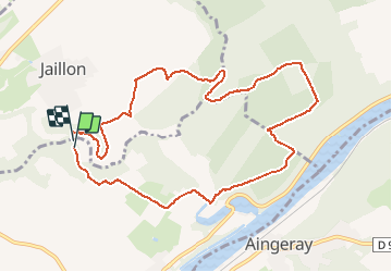

Length
9.9 km

Max alt
273 m

Uphill gradient
144 m
Km-Effort
11.9 km

Min alt
195 m

Downhill gradient
163 m
Boucle
Yes
Creation date :
2016-06-30 00:00:00.0
Updated on :
2016-06-30 00:00:00.0
1h39
Difficulty : Unknown

FREE GPS app for hiking
 SityTrail
IGN / Geographical institutes
SityTrail Plus
The world is yours!
About
Trail Other activity of 9.9 km to be discovered at Grand Est, Meurthe-et-Moselle, Villey-Saint-Étienne. This trail is proposed by sandra54570.
Photos


Positioning
Country:
France
Region :
Grand Est
Department/Province :
Meurthe-et-Moselle
Municipality :
Villey-Saint-Étienne
Location:
Unknown
Start:(Dec)
Start:(UTM)
718320 ; 5403887 (31U) N.
Comments