


passerelles himalayenne du monteynard avec vidéo

bob2023
User
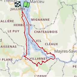

Length
15.3 km

Max alt
692 m

Uphill gradient
496 m
Km-Effort
22 km

Min alt
470 m

Downhill gradient
492 m
Boucle
Yes
Creation date :
2018-08-26 08:32:14.271
Updated on :
2018-10-19 20:42:27.644
4h50
Difficulty : Easy

FREE GPS app for hiking
 SityTrail
IGN / Geographical institutes
SityTrail Plus
The world is yours!
About
Trail Walking of 15.3 km to be discovered at Auvergne-Rhône-Alpes, Isère, Treffort. This trail is proposed by bob2023.
Photos


Positioning
Country:
France
Region :
Auvergne-Rhône-Alpes
Department/Province :
Isère
Municipality :
Treffort
Location:
Unknown
Start:(Dec)
Start:(UTM)
710927 ; 4976106 (31T) N.
Comments