


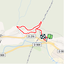
Circuit des Cascades-thones

bob2023
User


1h33
Difficulty : Medium

FREE GPS app for hiking
 SityTrail
IGN / Geographical institutes
SityTrail Plus
The world is yours!
About
Trail Walking of 3.1 km to be discovered at Auvergne-Rhône-Alpes, Upper Savoy, Thônes. This trail is proposed by bob2023.
Description
Parking au niveau du restaurant de Morette.
Ballade sympathique à l'ombre, mais avec un important dénivelé dès le départ de la randonnée. de jolies petites cascades sur le parcours. Attention la montée est rude pour des personnes âgées
Positioning
Comments